
Portal:Myanmar
ကြိုဆိုပါတယ်။ / Welcome to the Myanmar Portal 

Myanmar, officially the Republic of the Union of Myanmar and also known as Burma (the official name until 1989), is a country in Southeast Asia. It is the largest country by area in Mainland Southeast Asia and has a population of about 55 million. It is bordered by Bangladesh and India to its northwest, China to its northeast, Laos and Thailand to its east and southeast, and the Andaman Sea and the Bay of Bengal to its south and southwest. The country's capital city is Naypyidaw, and its largest city is Yangon (formerly Rangoon).
Myanmar is a member of the East Asia Summit, Non-Aligned Movement, ASEAN, and BIMSTEC, but it is not a member of the Commonwealth of Nations despite once being part of the British Empire. Myanmar is a Dialogue Partner of the Shanghai Cooperation Organization. The country is very rich in natural resources, such as jade, gems, oil, natural gas, teak and other minerals, as well as also endowed with renewable energy, having the highest solar power potential compared to other countries of the Great Mekong Subregion. However, Myanmar has long suffered from instability, factional violence, corruption, poor infrastructure, as well as a long history of colonial exploitation with little regard to human development. In 2013, its GDP (nominal) stood at US$56.7 billion and its GDP (PPP) at US$221.5 billion. The income gap in Myanmar is among the widest in the world, as a large proportion of the economy is controlled by cronies of the military junta. Myanmar is one of the least developed countries; as of 2020, according to the Human Development Index, it ranks 147 out of 189 countries in terms of human development, the lowest in Southeast Asia. Since 2021, more than 600,000 people were displaced across Myanmar due to the surge in violence post-coup, with more than 3 million people in dire need of humanitarian assistance. (Full article...)
Selected articles -
-
![Image 1 The Rohingya people (/roʊˈhɪndʒə, -ɪŋjə/; Rohingya: 𐴌𐴗𐴥𐴝𐴙𐴚𐴒𐴙𐴝, IPA: [rʊˈɜi̯ɲ.ɟə]) are a stateless Indo-Aryan ethnic group who predominantly follow Islam and reside in Rakhine State, Myanmar. Before the Rohingya genocide in 2017, when over 740,000 fled to Bangladesh, an estimated 1.4 million Rohingya lived in Myanmar. Described by journalists and news outlets as one of the most persecuted minorities in the world, the Rohingya are denied citizenship under the 1982 Myanmar nationality law. There are also restrictions on their freedom of movement, access to state education and civil service jobs. The legal conditions faced by the Rohingya in Myanmar have been compared to apartheid by some academics, analysts and political figures, including Nobel laureate Bishop Desmond Tutu, a South African anti-apartheid activist. The most recent mass displacement of Rohingya in 2017 led the International Criminal Court to investigate crimes against humanity, and the International Court of Justice to investigate genocide. The Rohingya maintain they are indigenous to western Myanmar with a heritage of over a millennium and influence from the Arabs, Mughals, and Portuguese. The community claims it is descended from people in precolonial Arakan and colonial Arakan; historically, the region was an independent kingdom between Southeast Asia and the Indian subcontinent. The Myanmar government considers the Rohingya as British colonial and postcolonial migrants from Chittagong in Bangladesh. It argues that a distinct precolonial Muslim population is recognized as Kaman, and that the Rohingya conflate their history with the history of Arakan Muslims in general to advance a separatist agenda. In addition, Myanmar's government does not recognise the term "Rohingya" and prefers to refer to the community as "Bengali". Rohingya campaign groups and human rights organizations demand the right to "self-determination within Myanmar". (Full article...)](//upload.wikimedia.org/wikipedia/en/d/d2/Blank.png)
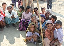
The Rohingya people (/roʊˈhɪndʒə, -ɪŋjə/; Rohingya: 𐴌𐴗𐴥𐴝𐴙𐴚𐴒𐴙𐴝, IPA: [rʊˈɜi̯ɲ.ɟə]) are a stateless Indo-Aryan ethnic group who predominantly follow Islam and reside in Rakhine State, Myanmar. Before the Rohingya genocide in 2017, when over 740,000 fled to Bangladesh, an estimated 1.4 million Rohingya lived in Myanmar. Described by journalists and news outlets as one of the most persecuted minorities in the world, the Rohingya are denied citizenship under the 1982 Myanmar nationality law. There are also restrictions on their freedom of movement, access to state education and civil service jobs. The legal conditions faced by the Rohingya in Myanmar have been compared to apartheid by some academics, analysts and political figures, including Nobel laureate Bishop Desmond Tutu, a South African anti-apartheid activist. The most recent mass displacement of Rohingya in 2017 led the International Criminal Court to investigate crimes against humanity, and the International Court of Justice to investigate genocide.
The Rohingya maintain they are indigenous to western Myanmar with a heritage of over a millennium and influence from the Arabs, Mughals, and Portuguese. The community claims it is descended from people in precolonial Arakan and colonial Arakan; historically, the region was an independent kingdom between Southeast Asia and the Indian subcontinent. The Myanmar government considers the Rohingya as British colonial and postcolonial migrants from Chittagong in Bangladesh. It argues that a distinct precolonial Muslim population is recognized as Kaman, and that the Rohingya conflate their history with the history of Arakan Muslims in general to advance a separatist agenda. In addition, Myanmar's government does not recognise the term "Rohingya" and prefers to refer to the community as "Bengali". Rohingya campaign groups and human rights organizations demand the right to "self-determination within Myanmar". (Full article...) -

The British colonial rule in Burma lasted from 1824 to 1948, from the successive three Anglo-Burmese wars through the creation of Burma as a province of British India to the establishment of an independently administered colony, and finally independence. The region under British control was known as British Burma, and officially known as Burma (Burmese: မြန်မာနိုင်ငံတော်) from 1886. Various portions of Burmese territories, including Arakan and Tenasserim, were annexed by the British after their victory in the First Anglo-Burmese War; Lower Burma was annexed in 1852 after the Second Anglo-Burmese War. The annexed territories were designated the minor province (a chief commissionership) of British Burma in 1862.
After the Third Anglo-Burmese War in 1885, Upper Burma was annexed, and the following year, the province of Burma in British India was created, becoming a major province (a lieutenant-governorship) in 1897. This arrangement lasted until 1937, when Burma began to be administered separately by the Burma Office under the Secretary of State for India and Burma. British rule was disrupted during the Japanese occupation of much of the country during World War II. Burma achieved independence from British rule on 4 January 1948. (Full article...) -
Zigrasimecia is an extinct genus of ants which existed in the Cretaceous period approximately 98 million years ago. The first specimens were collected from Burmese amber in Kachin State, 100 kilometres (62 mi) west of Myitkyina town in Myanmar. In 2013, palaeoentomologists Phillip Barden and David Grimaldi published a paper describing and naming Zigrasimecia tonsora. They described a dealate female with unusual features, notably the highly specialized mandibles. Other features include large ocelli, short scapes, 12 antennomeres, small eyes, and a clypeal margin that has a row of peg-like denticles. The genus Zigrasimecia was originally incertae sedis (uncertain placement) within Formicidae until a second species, Zigrasimecia ferox, was described in 2014, leading to its placement in the subfamily Sphecomyrminae. Later, it was considered to belong to the distinct subfamily Zigrasimeciinae.
Due to the highly specialized mandibles, scientists believe that the ants exhibited habits no longer seen in extant ants. The highly movable head suggests that mobility was an important factor for them (probably for feeding behavior), and the rugose projections may have played a major role in nest excavation because the mandibles would have prevented such activity. Zigrasimecia most likely interacted with the extinct ant genus Gerontoformica through conflict and probably shared some of their ecological niches. The mandibles of these ants were probably used for mechanical interactions with food, and they may also have served as traps for potential arthropod prey such as mites and small flies. Zigrasimecia was possibly a generalist predator. (Full article...) -
Ne Win (Burmese: နေဝင်း; IPA: [nè wɪ́ɰ̃]; 24 May 1911 – 5 December 2002), born Shu Maung (Burmese: ရှူမောင်; IPA: [/ʃù màʊ̃̀/]), was a Burmese army general, politician and military commander who served as Prime Minister of Burma from 1958 to 1960 and 1962 to 1974, and also President of Burma from 1962 to 1981. Ne Win was Burma's military dictator during the Socialist Burma period of 1962 to 1988.
Ne Win founded the Burma Socialist Programme Party (BSPP) and overthrew the democratic Union Parliament of U Nu in the 1962 Burmese coup d'état, establishing Burma as a one-party socialist state under the Burmese Way to Socialism ideology. Ne Win was Burma's de facto leader as chairman of the BSPP, serving in various official titles as part of his military government, and was known by his supporters as U Ne Win. His rule was characterized by a non-aligned foreign policy, isolationism, one-party rule, economic stagnation, and superstition. Ne Win resigned in July 1988 in response to the 8888 Uprising that overthrew the Burma Socialist Programme Party (BSPP), and was replaced by the military junta of the State Law and Order Restoration Council (SLORC). He held minor influence in the 1990s but was eventually placed under house arrest, under which he died in 2002. (Full article...) -
The Irrawaddy River (Burmese: ဧရာဝတီမြစ်, pronounced [ʔèjàwədì mjɪʔ], official romanisation: Ayeyarwady) is the largest river in Myanmar. Originating from the confluence of the N'mai and Mali rivers, it flows from north to south before emptying through the Irrawaddy Delta in the Ayeyarwady Region into the Andaman Sea. Its drainage basin of about 404,000 square kilometres (156,000 sq mi) covers 61% of the land area of Burma, and contains five of its largest cities.
As early as the sixth century, the river was used for trade and transport, and an extensive network of irrigation canals was developed to support agriculture. The river is still of great importance as the largest commercial waterway of Myanmar. It also provides important ecosystem services to different communities and economic sectors, including agriculture, fisheries, and tourism. (Full article...) -
The sun bear (Helarctos malayanus) is a species in the family Ursidae (the only species in the genus Helarctos) occurring in the tropical forests of Southeast Asia. It is the smallest bear species, standing nearly 70 cm (28 in) at the shoulder and weighing 25–65 kg (55–143 lb). It is stockily built, with large paws, strongly curved claws, small, rounded ears and a short snout. The fur is generally short and jet black, but can vary from grey to red. The sun bear gets its name from its characteristic orange to cream-coloured chest patch. Its unique morphology—inward-turned front feet, flattened chest, powerful forelimbs with large claws—suggests adaptations for climbing.
The most arboreal (tree-living) of all bears, the sun bear is an excellent climber and sunbathes or sleeps in trees 2 to 7 m (7 to 23 ft) above the ground. It is mainly active during the day, though nocturnality might be more common in areas frequented by humans. Sun bears tend to remain solitary, but sometimes occur in twos (such as a mother and her cub). They do not seem to hibernate, possibly because food resources are available the whole year throughout the range. Being omnivores, sun bears' diet includes ants, bees, beetles, honey, termites, and plant material such as seeds and several kinds of fruits; vertebrates such as birds and deer are also eaten occasionally. They breed throughout the year; individuals become sexually mature at two to four years of age. Litters comprise one or two cubs that remain with their mother for around three years. (Full article...) -
The Kuomintang in Burma or Kuomintang in the Golden Triangle were Kuomintang (Chinese Nationalist) troops that fled from China to Burma in 1950 after their defeat by the Chinese communists in the Chinese Civil War. They were commanded by General Li Mi. It attempted several incursions into Yunnan in the early 1950s, only to be pushed back into Burma each time by the Chinese Communist Party's People's Liberation Army.
The entire campaign, with logistical support from the Republic of China which had retreated to Taiwan, the United States, and Thailand, was controversial from the start, as it weakened Burmese sovereignty and introduced the KMT's involvement in the region's lucrative opium trade. In 1953, the frustrated Burmese government appealed to the United Nations and put international pressure on the Republic of China to withdraw its troops to Taiwan the following year. As a result, the United States initiated a Four-Nation Military Commission (Burma, the United States, the Republic of China, and Thailand) to negotiate the KMT withdrawal. On 30 May 1954, General Li Mi announced the dissolution of the Yunnan Province Anticommunist National Salvation Army. However, 6,000 irregular KMT troops remained in Burma. Fighting continued sporadically from the irregular troops until coordinated military operations from 1960 to 1961 between the PRC and Burmese governments expelled the remaining irregular KMT troops from Burma. Though most were evacuated to Taiwan, some remained in Burma or formed communities in Thailand. (Full article...) -
The 1962 Burmese coup d'état marked the beginning of one-party rule in Burma (Myanmar) and the political dominance of the military in Burmese politics. In the 2 March 1962 coup, the military replaced the civilian AFPFL-government headed by Prime Minister U Nu, along with the Union Revolutionary Council Chaired by General Ne Win.
In the first 12 years following the coup, the country was ruled under martial law, and saw a significant expansion in the military's role in the national economy, politics, and state bureaucracy. Following the constitution of 1974, the Revolutionary Council handed over the power to the elected government, consisting of a single-party, the Burma Socialist Programme Party, which had been founded by the council in 1962. The elected government remained hybrid between civilian and military, until 18 September 1988, when the military again took over as the State Law and Order Restoration Council (then renamed the State Peace and Development Council) following the nationwide 8888 Uprising and virtual breakdown of the socialist regime. The military junta retained power for 23 years until 2011, when it was transferred to the Union Solidarity and Development Party. (Full article...) -
The University of Yangon (also Yangon University; Burmese: ရန်ကုန် တက္ကသိုလ်, pronounced [jàɰ̃ɡòʊɰ̃ tɛʔkəθò]; formerly Rangoon College, Rangoon University and Rangoon Arts and Sciences University), located in Kamayut, Yangon, is the oldest university in Myanmar's modern education system and the best known university in Myanmar. The university offers mainly undergraduate and postgraduate degrees (Bachelor's, Master's, Post-graduate Diploma, and Doctorate) programs in liberal arts, sciences and law. Full-time bachelor's degrees were not offered at the university's main campus after the student protests of 1996. The bachelor's degree was re-offered from 2014 on. Today degrees in Political Science are offered to undergraduate students, as well as postgraduate diplomas in areas such as social work and geology.
Initially most major universities in the country depended on Yangon University. Until 1958 when Mandalay University became an independent university, all institutions of higher education in Myanmar were under Yangon University. After the University Education Act of 1964, all professional colleges and institutes of the university such as the Institute of Medicine 1, Rangoon Institute of Technology and Yangon Institute of Economics became independent universities, leaving the Yangon University with liberal arts, sciences and law. In Myanmar, responsibility for higher education depends on various ministries. The University of Yangon depends from the Ministry of education. (Full article...) -
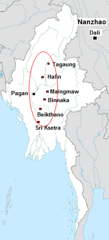
The Early Pagan Kingdom (Burmese: ခေတ်ဦး ပုဂံ ပြည်) was a city-state that existed in the first millennium CE before the emergence of the Pagan Empire in the mid 11th century. The Burmese chronicles state that the "kingdom" was founded in the second century CE. The seat of power of the small kingdom was first located at Arimaddana, Thiri Pyissaya, and Tampawaddy until 849 CE when it was moved to Pagan (Bagan).
Radiocarbon dating shows the earliest human settlement in the Pagan region dates only from the mid-7th century CE. It existed alongside Pyu city-states that dominated Upper Burma. The city-state of Pagan, according to mainstream scholarship, was founded in the mid 9th century by the Mranma of Nanzhao Kingdom. Burmans at Pagan expanded irrigation-based cultivation while borrowing extensively from the Pyus' predominantly Buddhist culture. It was one of many competing city-states in the Pyu realm until the late 10th century when the principality began absorbing its surrounding states. The expansion accelerated in the 1050s and 1060s when King Anawrahta founded the Pagan Empire, the first ever unification of the Irrawaddy valley and its periphery. (Full article...)
![Image 1 The Rohingya people (/roʊˈhɪndʒə, -ɪŋjə/; Rohingya: 𐴌𐴗𐴥𐴝𐴙𐴚𐴒𐴙𐴝, IPA: [rʊˈɜi̯ɲ.ɟə]) are a stateless Indo-Aryan ethnic group who predominantly follow Islam and reside in Rakhine State, Myanmar. Before the Rohingya genocide in 2017, when over 740,000 fled to Bangladesh, an estimated 1.4 million Rohingya lived in Myanmar. Described by journalists and news outlets as one of the most persecuted minorities in the world, the Rohingya are denied citizenship under the 1982 Myanmar nationality law. There are also restrictions on their freedom of movement, access to state education and civil service jobs. The legal conditions faced by the Rohingya in Myanmar have been compared to apartheid by some academics, analysts and political figures, including Nobel laureate Bishop Desmond Tutu, a South African anti-apartheid activist. The most recent mass displacement of Rohingya in 2017 led the International Criminal Court to investigate crimes against humanity, and the International Court of Justice to investigate genocide. The Rohingya maintain they are indigenous to western Myanmar with a heritage of over a millennium and influence from the Arabs, Mughals, and Portuguese. The community claims it is descended from people in precolonial Arakan and colonial Arakan; historically, the region was an independent kingdom between Southeast Asia and the Indian subcontinent. The Myanmar government considers the Rohingya as British colonial and postcolonial migrants from Chittagong in Bangladesh. It argues that a distinct precolonial Muslim population is recognized as Kaman, and that the Rohingya conflate their history with the history of Arakan Muslims in general to advance a separatist agenda. In addition, Myanmar's government does not recognise the term "Rohingya" and prefers to refer to the community as "Bengali". Rohingya campaign groups and human rights organizations demand the right to "self-determination within Myanmar". (Full article...)](/wiki/File:Blank.png)
_(cropped).jpg)
.svg)

.jpg)


Did you know (auto-generated) -

- ... that the Burmese and South Korean first ladies held their first informal conversation 44 years after the establishment of bilateral relations between the two countries?
- ... that the mission of the United Nations special envoy on Myanmar has been called a "diplomatic graveyard"?
- ... that Maung O, Prince of Salin, and his sister Nanmadaw Me Nu became de facto rulers of Burma when King Bagyidaw was suffering from depression?
- ... that Molly Burman resumed releasing music three years later after finding that "Happy Things" had accrued a million streams on Spotify?
- ... that while defending Zaw Myint Maung following his arrest by the Myanmar junta, lawyer Ywet Nu Aung was herself arrested and charged?
- ... that squatters in Myanmar were punished for protesting against the 2021 coup d'état by being evicted?
- ... that Rolling Stone named Mission of Burma's "Academy Fight Song" as one of the 100 greatest debut singles of all time?
- ... that Rangoon kept its own time for more than two decades after Burma Standard Time first came into effect?
Related portals and projects
General images -
-
 Temples at Mrauk U, was the capital of the Mrauk U Kingdom, which ruled over what is now Rakhine State. (from History of Myanmar)
 -
 The restored Taungoo or Nyaungyan dynasty c. 1650 CE. (from History of Myanmar)
 -
 Salween river at Mae Sam Laep on the Thai-Myanmar border (from Geography of Myanmar)
 -
 Portuguese ruler and soldiers mounting an Elephant. Philips, Jan Caspar (draughtsman and engraver) (from History of Myanmar)
 -
 Myinhkin thabin - equestrian sport (from Culture of Myanmar)
 -
 Aerial view of a burned Rohingya village in Rakhine state, Myanmar, September 2017 (from History of Myanmar)
 -
 19th-century funeral cart and spire, which would form part of the procession from the home to the place of cremation (from Culture of Myanmar)
 -
 Pagan Kingdom during Narapatisithu's reign. Burmese chronicles also claim Kengtung and Chiang Mai. Core areas shown in darker yellow. Peripheral areas in light yellow. Pagan incorporated key ports of Lower Burma into its core administration by the 13th century. (from History of Myanmar)
 -
 Protesters in Yangon with a banner that reads non-violence: national movement in Burmese, in the background is Shwedagon Pagoda. (from History of Myanmar)
 -
 British soldiers remove their shoes at the entrance of Shwedagon Pagoda. To the left, a sign reads "Foot wearing is strictly prohibited" in Burmese, English, Tamil, and Urdu. (from Culture of Myanmar)
 -
 Jade Mine in Hpakant (from Geography of Myanmar)
 -
 Hlei pyaingbwè - a Burmese regatta (from Culture of Myanmar)
 -
 The paddle steamer Ramapoora (right) of the British India Steam Navigation Company on the Rangoon river having just arrived from Moulmein. 1895. Photographers: Watts and Skeen (from History of Myanmar)
 -

-

-
 A theatrical performance of the Mon dance (from Culture of Myanmar)
 -
 British soldiers dismantling cannons belonging to King Thibaw's forces, Third Anglo-Burmese War, Ava, 27 November 1885. Photographer: Hooper, Willoughby Wallace (1837–1912). (from History of Myanmar)
 -
 Grandfather Island, Dawei (from Geography of Myanmar)
 -
 Recorder's Court on Sule Pagoda Road, with the Sule Pagoda at the far end, Rangoon, 1868. Photographer: J. Jackson. (from History of Myanmar)
 -
 Protesters in Yangon carrying signs reading "Free Daw Aung San Suu Kyi" on 8 February 2021. (from History of Myanmar)
 -
 Boxing match, 19th-century watercolour (from Culture of Myanmar)
 -
 Former US President Barack Obama poses barefoot on the grounds of Shwedagon Pagoda, one of Myanmar's major Buddhist pilgrimage sites. (from Culture of Myanmar)
 -
 Vegetable stall on the roadside at the Madras Lancer Lines, Mandalay, January 1886. Photographer: Hooper, Willoughby Wallace (1837–1912). (from History of Myanmar)
 -
 Mount Popa, a dormant volcano in the Central Lowlands (from Geography of Myanmar)
 -
 A wedding procession, with the groom and bride dressed in traditional Burmese wedding clothes, reminiscent of royal attire (from Culture of Myanmar)
 -
 A wide range of Burmese lacquerware from Bagan (from Culture of Myanmar)
 -
 British soldiers on patrol in the ruins of the Burmese town of Bahe during the advance on Mandalay, January 1945. (from History of Myanmar)
 -
 Saint Mary's Cathedral in Downtown Yangon is the largest Roman Catholic cathedral in Burma. (from Culture of Myanmar)
 -
 The shores of Irrawaddy River at Nyaung-U, Bagan (from Geography of Myanmar)
 -

-
 A bull fight, 19th-century watercolour (from Culture of Myanmar)
 -
 A group of Buddhist worshipers at Shwedagon Pagoda, an important religious site for Burmese Buddhists (from Culture of Myanmar)
 -
 Aung San Suu Kyi addresses crowds at the NLD headquarters shortly after her release. (from History of Myanmar)
 -
 Myanmar (Burma) map of Köppen climate classification (from Geography of Myanmar)
 -
 Political Map of Burma (Myanmar) c. 1450 CE. (from History of Myanmar)
 -
 Mountains near Pindaya on the Shan Plateau (from Geography of Myanmar)
 -
 Sculpture of Myanmar mythical lion (from Culture of Myanmar)
 -

-
 Two female musicians play the saung at a performance in Mandalay. (from Culture of Myanmar)
 -
 A large fracture on the Mingun Pahtodawgyi caused by the 1839 Ava earthquake. (from Geography of Myanmar)


_headquarter.jpg)


Major topics
Categories

More topics

Associated Wikimedia
The following Wikimedia Foundation sister projects provide more on this subject:
-
 Commons
Free media repository -
 Wikibooks
Free textbooks and manuals -
 Wikidata
Free knowledge base -
 Wikinews
Free-content news -
 Wikiquote
Collection of quotations -
 Wikisource
Free-content library -
 Wikiversity
Free learning tools -
 Wikivoyage
Free travel guide -
 Wiktionary
Dictionary and thesaurus


